

Sea-Level Rise: Global Legal Response and India’s Coastal Vulnerability

Sea-Level Rise: Global Legal Response and India’s Coastal Vulnerability
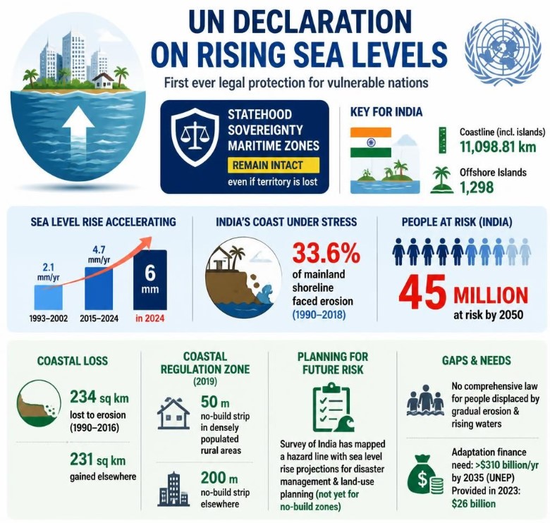
UN Declaration on Sea-Level Rise
- The UN General Assembly adopted its first-ever declaration on rising sea levels, recognising the threat to vulnerable coastal and island states.
- It calls for sea-level rise projections to be incorporated into coastal infrastructure and planning.
- It supports a presumption in favour of continued statehood for countries whose territory becomes uninhabitable or submerged.
- Such states would retain sovereignty, UN membership and maritime rights despite physical loss of territory.
- It also emphasises protection of displaced populations and promotes “mobility with dignity”.
Accelerating Sea-Level Rise
- According to the World Meteorological Organization, the global rate of sea-level rise increased from 2.1 mm/year during 1993–2002 to 4.7 mm/year during 2015–2024.
- Sea level rose by around 6 mm in 2024, the highest annual increase recorded.
- Under a low-emission pathway, global sea level could rise by around 38 cm by 2100 compared with early-2000s levels.
- Under a high-emission pathway, the rise could reach around 77 cm.
- Even after achieving net-zero emissions, sea levels will continue rising for centuries to millennia because of the long-term response of oceans and ice sheets.
Statehood and Maritime Rights
- The Montevideo Convention, 1933 identifies four traditional criteria of statehood: permanent population, defined territory, government and capacity to enter relations with other states.
- Rising seas create uncertainty over whether a state can continue to exist if its territory becomes submerged or uninhabitable.
- The UN declaration supports continued statehood despite such physical changes.
- It also supports continuity of maritime zones:
- Territorial Sea: up to 12 nautical miles from the baseline.
- Exclusive Economic Zone (EEZ): up to 200 nautical miles, within which a coastal state has sovereign rights over natural resources.
- This is particularly important for small island states whose maritime resources extend far beyond their shrinking land territory.
India’s Coastal Vulnerability
- India has around 11,098 km of coastline, including the mainland and islands.
- Lakshadweep and the Andaman and Nicobar Islands extend India's maritime presence into the Arabian Sea and Bay of Bengal.
- The National Centre for Coastal Research has identified significant shoreline erosion along parts of India's coast.
- Around 400 km of coastline is retreating by more than 5 metres annually, while another 225 km is retreating by 3–5 metres annually.
- West Bengal has a significant share of the rapidly eroding coastline, particularly in the Sundarbans.
- Sea-level rise threatens coastal settlements, infrastructure, fisheries, livelihoods and marine ecosystems.
Adaptation Gap and Way Forward
- Under the 2019 Coastal Regulation Zone Notification, restrictions are primarily linked to the present High Tide Line rather than the projected future shoreline.
- The Survey of India has prepared a hazard line incorporating factors such as coastal flooding, erosion and sea-level rise, but its use remains largely limited to disaster-management planning.
- Ghoramara Island in the Sundarbans demonstrates the human consequences of long-term coastal erosion.
- India lacks a comprehensive legal framework specifically addressing slow-onset climate displacement.
- India needs to incorporate projected sea-level rise into coastal zoning, strengthen protection for climate-displaced communities and provide land titles and livelihood support after relocation.
- Coastal ecosystem restoration, climate-resilient infrastructure and stronger early-warning systems should form part of adaptation planning.
- India should continue seeking greater international climate finance for adaptation, guided by the principle of Common but Differentiated Responsibilities and Respective Capabilities (CBDR-RC).