

Silt in Rivers to Urbanisation: Behind Kerala's Worsening Floods

Silt in Rivers to Urbanisation: Behind Kerala's Worsening Floods
Relevance: GS Paper I (Geography, Drainage Systems) | GS Paper III (Disaster Management, Environment, Urbanisation)
Why in the News?
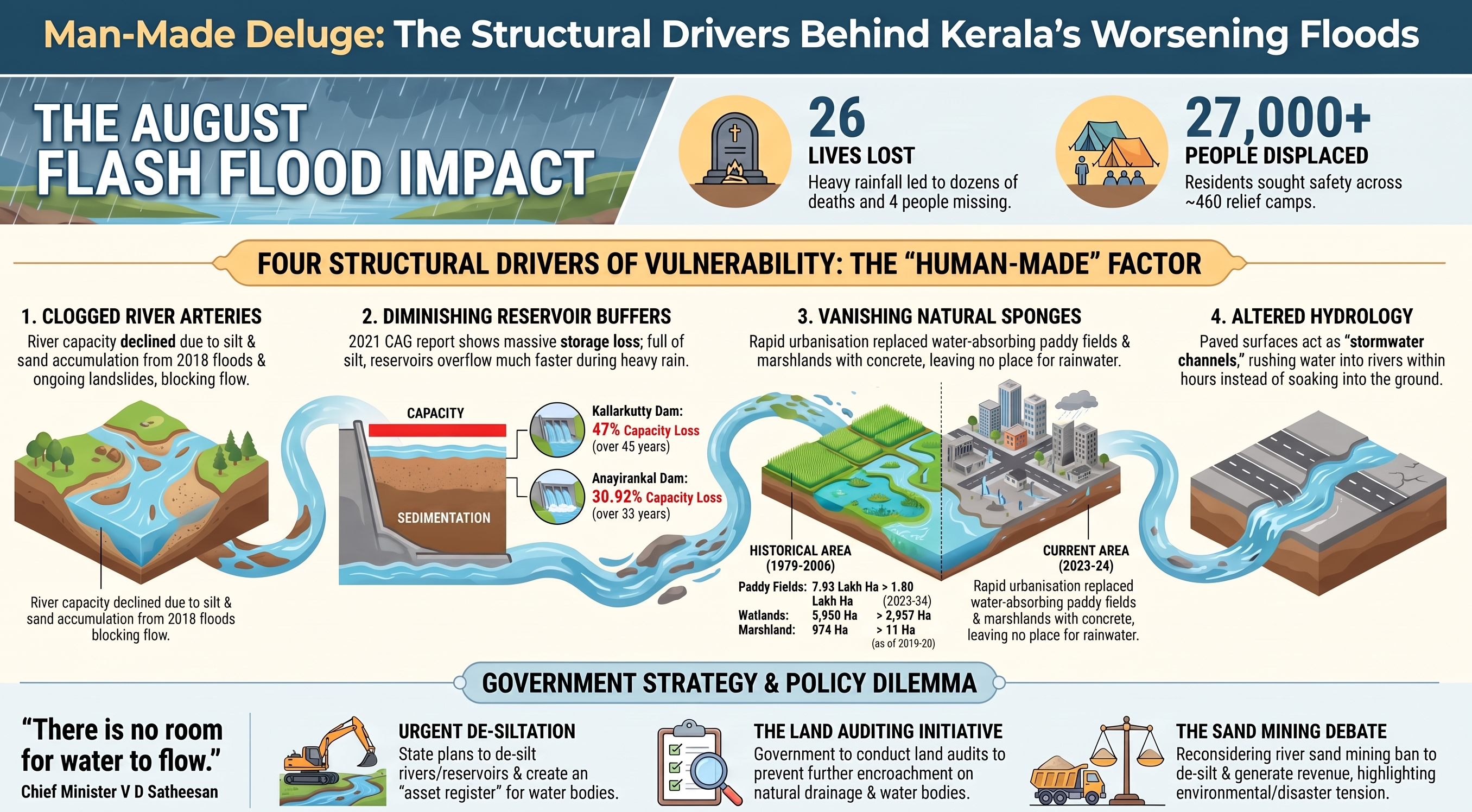
An unexpected spell of extremely heavy rainfall in early August triggered flash floods across Kerala, worst affecting Kottayam, Pathanamthitta, and Alappuzha. Per Chief Minister V D Satheesan, 26 people were killed, 4 remained missing, and over 27,000 people were sheltering across ~460 relief camps. The scale of the crisis points less to rainfall alone and more to a set of largely human-made vulnerabilities that have accumulated over decades.
Four Structural Drivers
- Reduced river carrying capacity: Kerala's irrigation department studies show river water-holding capacity has significantly declined due to silt and sand accumulation over the past decade. The 2018 floods deposited large sediment volumes into rivers, and landslides in hilly/forested areas have continued adding soil and sand to riverbeds. This sedimentation has also formed deltas that obstruct floodwater flow.
- Sedimented reservoirs: A 2021 CAG report found significant storage capacity loss in dams due to sedimentation — the Kallarkutty dam lost 47% of gross storage over 45 years, and the Anayirankal dam lost 30.92% over 33 years. With extremely heavy rain raising water levels in all dams (both electricity board- and irrigation department-run), reduced storage capacity leaves far less buffer before overflow.
- Disappearing wetlands and paddy fields: Rapid urbanisation and land-use change have sharply shrunk natural water-absorption systems. Paddy land fell from 7.93 lakh hectares (1979-80) to 2.05 lakh hectares (2020-21) and further to 1.80 lakh hectares (2023-24). Marshland fell from 974 hectares (2005-06) to a mere 11 hectares (2019-20). Wetlands shrank from 5,950 hectares (2005-06) to 2,937 hectares (2023-24) — removing natural sponges that once absorbed heavy rainfall.
- Altered natural hydrology: Kerala's dense network of concrete roads, tarred lanes, and paved surfaces (across both rural and urban areas) has fundamentally changed how the state's landscape handles rain. These impervious surfaces channel stormwater rapidly into rivers and streams instead of allowing absorption, causing water levels to rise within hours — effectively turning roads descending from hills and highlands into stormwater channels.
Government Response
The state plans to de-silt rivers and reservoirs to restore water-holding capacity. CM Satheesan noted: "There is no room for water to flow," announcing urgent desedimentation of rivers and dams, an asset register for rivers/streams/lakes, and land auditing to prevent encroachment. Notably, sand mining from rivers — once widespread but banned a decade ago over environmental concerns — is being considered again as both a desiltation method and a potential revenue source, illustrating the tension between environmental caution and practical flood management.
Significance for Mains
- A clear illustration of how disaster risk is co-produced by climate variability and human land-use decisions — heavy rainfall is the trigger, but reduced carrying capacity (rivers, reservoirs) and lost natural buffers (wetlands, paddy fields) determine the scale of damage.
- Connects to the broader debate on Western Ghats ecological sensitivity (covered in an earlier note) — unregulated hill-area construction and deforestation directly feed sediment into rivers downstream.
- Highlights the policy tension between environmental protection (the sand-mining ban) and infrastructure/flood-management needs — a recurring theme in India's environment-development trade-off debates.
- Useful for questions on urban flooding, wetland conservation (Ramsar obligations), dam siltation management, and disaster risk reduction frameworks (e.g., the Sendai Framework's emphasis on addressing underlying risk drivers, not just hazard response).