

Why a Flat Map Fails to Accurately Depict Earth?

Why in News?
The United Nations has renewed discussions around the use of alternative world map projections, highlighting concerns associated with the continued use of the Mercator projection for representing the world.
The issue centres on the difficulty of accurately representing the Earth's curved surface on a two-dimensional map.
Earth and the Problem of Map Projection
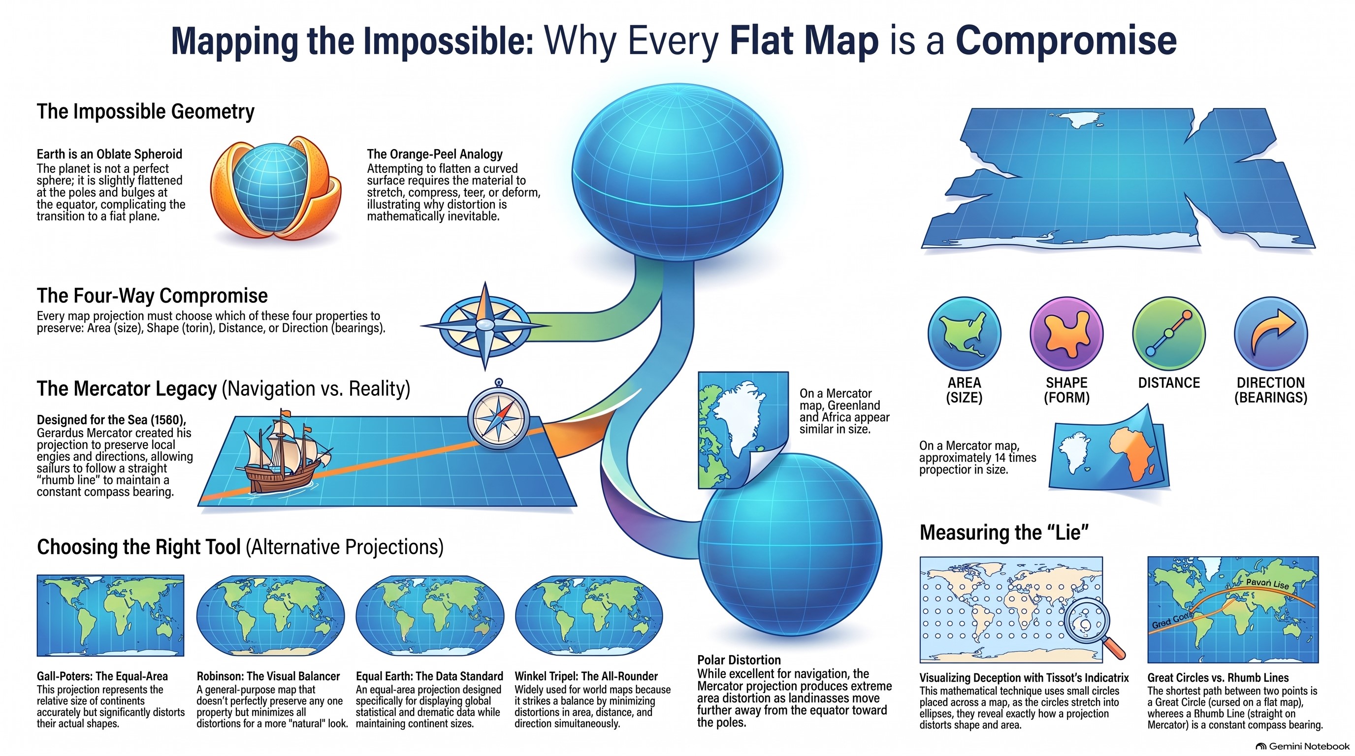
· The Earth is not a perfect sphere but an oblate spheroid, slightly flattened at the poles and bulging at the equator.
· A map, however, represents the Earth's surface on a two-dimensional plane. It is mathematically impossible to transfer a curved surface onto a flat surface without introducing distortion.
· This can be understood through the orange-peel analogy: when an orange peel is flattened, it must either stretch, compress, tear or deform.
Therefore, every map projection involves some compromise between four major properties:
- Area – relative size of landmasses
- Shape – actual form of geographical features
- Distance – distance between locations
- Direction – compass bearings between locations
No single projection can preserve all four properties simultaneously across the entire globe.
Mercator Projection
· The Mercator projection, developed by Gerardus Mercator in 1569, represents the Earth's surface as though it were projected onto a cylinder.
· Its major feature is the preservation of local angles and directions, making it particularly useful for navigation.
· A straight line on a Mercator map represents a rhumb line, which maintains a constant compass bearing.
· However, the projection produces considerable area distortion, particularly towards the poles.
· For instance, Greenland appears disproportionately large, while Africa appears much closer in size to Greenland than it actually is. In reality, Africa is approximately 14 times larger than Greenland.
· Thus, Mercator is useful for navigation but unsuitable for accurately comparing the actual sizes of continents and countries.
Alternative Map Projections
Different projections have been developed to reduce particular forms of distortion.
Gall-Peters Projection
- An equal-area projection.
- Represents the relative size of continents more accurately.
- Distorts the shape of landmasses.
Robinson Projection
- Attempts to balance different types of distortion.
- Produces a visually balanced representation of the world.
- Suitable for general-purpose world maps.
Winkel Tripel Projection
- Attempts to minimise distortion in area, distance and direction.
- Has been widely used for general world maps.
Equal Earth Projection
- An equal-area projection.
- Maintains the relative size of continents.
- Particularly useful for displaying global statistical and thematic data.
- Compromises on the accurate representation of shapes.
Great Circles and Map Distortion
· The Great Circle represents the shortest route between two points on a spherical Earth.
· Because a flat map introduces distortion, a Great Circle route may appear as a curved line on many map projections.
· This is why international flight routes often appear curved on conventional world maps even though aircraft are following approximately the shortest route over the Earth's surface.
· In contrast, a rhumb line maintains a constant compass bearing and appears as a straight line on the Mercator projection.
Tissot's Indicatrix
Tissot's Indicatrix is not a map projection.
It is a mathematical technique used to visualise and measure distortion produced by a map projection.
Small circles placed across a map become distorted into ellipses, showing how the projection changes:
- Area
- Shape
- Distance
- Direction
The pattern and degree of deformation help identify the nature of distortion associated with a particular projection.
Conclusion
Every map projection involves a trade-off between geographical accuracy and practical utility. The choice of projection therefore depends on the purpose of the map—navigation, area comparison, general geographical representation or presentation of statistical data.